How Can You Measure Income Inequality? Count The Trees
Share
Explore Our Galleries
Breaking News!
Today's news and culture by Black and other reporters in the Black and mainstream media.
Ways to Support ABHM?
By Hattie Lee, Colorlines.com
Turns out there’s a direct correlation between the number of trees a neighborhood has and its monetary wealth —
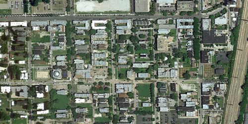
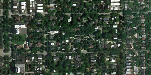
and we can see how this dynamic plays out from space. Environmental journalist Tim De Chant mapped it all out for us on his blog, Per Square Mile, where he worked up a small project called “Income Inequality, As Seen From Space.”
De Chant took satellite images from Google Earth that compared two neighborhoods from selected cities to show income disparities.
Hyde Park is home to the University of Chicago. It has the highest number of Nobel Prize winners per square kilometer of any neighborhood on earth.
In the 1950s it experienced “white flight” as a reaction to school desegregation. Today, largely as a result of the University of Chicago’s “urban renewal” (or “removal”) program, it is one of the most economically and social integrated neighborhoods in the US.
Woodlawn neighborhood, just to the south of Hyde Park, is known for its urban blight: high crime, vacant lots, and lack of businesses.



Comments Are Welcome
Note: We moderate submissions in order to create a space for meaningful dialogue, a space where museum visitors – adults and youth –– can exchange informed, thoughtful, and relevant comments that add value to our exhibits.
Racial slurs, personal attacks, obscenity, profanity, and SHOUTING do not meet the above standard. Such comments are posted in the exhibit Hateful Speech. Commercial promotions, impersonations, and incoherent comments likewise fail to meet our goals, so will not be posted. Submissions longer than 120 words will be shortened.
See our full Comments Policy here.